Social Studies
Objective: I can use a globe, a map key, directions, and a scale to read a map.
Standards: D2.Geo.1.3-5, D2.Geo.2.3-5, D2.Geo.3.3-5
Builds on: Needs everything from Days 1 to 4. One-minute check: your child points to the key and the compass rose on the Fern Park map. Your child tells what each is for.
Materials: Stored Week 3 Social Studies Check and its answer key, Fern Park map from Days 2 and 3, Town map with a scale from Day 4, Ruler marked in inches, Notebook, Pencil
- Day 15 — Week 3 Check: Maps and Globes — Big Question Warm-Up · 5 min
Spaced review from Week 2. Ask: "Give one clue for a suburban community." (Houses with yards near a city, or driveways and garages.) Then play Map Relay. Your child points to the key, the compass rose and the scale on the two maps. Ask the big question: "What can these three tools tell us?"
- Mini-Lesson · 10–15 min
Review the week's four ideas. 1) Ask: "Why does a flat map stretch some places?" (Earth is round, and flattening it stretches parts.) 2) Ask: "What do you read first on any map?" (The key.) 3) Say: "On a map, the school is below the park. What direction is the school from the park?" (South.) 4) Say: "The scale is 1 inch = 10 miles. Two cities are 8 inches apart." Your child counts by tens. (80 miles.) Ask: "80 what?" (Miles.) Say: "Always say the unit." If stuck on directions, say: "Draw a quick compass rose. Which way is down?" If stuck on scale, say: "Hop along the ruler and count ten for each inch."
- Activity / Source Work · 15–20 min
Play Map Challenge. 1) Your child draws a playground symbol southeast of the lake on the Fern Park map. Then your child adds it to the key. Look for: it sits to the lower right, and it is in the key. 2) Ask: "Which is farther north, the cabins or the picnic tables?" (The cabins.) 3) Ask: "I walk west from the forest to the picnic tables. What do I pass?" (The lake.) 4) On the town map, your child picks two towns not yet measured as a pair. Your child measures from zero, rounds to the nearest inch and counts by tens. Check the inches yourself. 5) Your child writes two map questions for you. One must need the key and one must need the scale. Answer them and let your child check you.
- Notebook Entry · 10 min
Keep this entry to about 5 minutes so the check fits. In the notebook, your child finishes in pencil: "My strongest map skill is ____. The hardest one is ____ because ____."
- Wrap-Up & Exit Ticket · 5 min
Ask the three exit questions aloud. Then give the stored Week 3 check: 7 items, about 15 minutes, not timed. Score it with the key. If your child is tired, give the check later the same day. 6 or more right: go on to Week 4. 4 or 5 right: redo the Day 4 measuring, then play Direction Walk from Day 3. 3 or fewer right: reteach Day 2 with the Fern Park map. Read the key first, then find 5 symbols. Praise answers that name the unit or the tool.
Watch for: Using the scale correctly but leaving off the unit.
Try: Ask "30 what?" after each answer until saying miles becomes a habit.
- Name the three map tools you used this week. Tell the job of one.
- Ben measures 5 inches between two farms. The scale says 1 inch = 10 miles. Ben says the farms are 5 miles apart. What did he forget?
- On a map, a bridge is in the bottom left corner and a tower is in the center. What direction is the bridge from the tower?
Show answers
- The key, the compass rose and the scale. Look for one job, such as: the key tells what symbols mean.
- He forgot to use the scale. Count by tens: the farms are 50 miles apart.
- Southwest.
Support: Read each check item aloud. Your child may point on the Fern Park map while thinking.
Extend: Your child adds a scale to a new treasure map, such as 1 inch = 1 big step. Then your child writes three direction clues.
Homework: Hide a small object at home. Your child draws a treasure map with a key and a compass rose. Look for: three clues that use direction words.
Practice page · Week 3, Day 5
Social Studies
I can get ready by reading a whole map.
Map of Pine Valley
Scale: 1 inch = 10 miles. Key: a star in a circle means the state capital. A dot means a town. A blue line means a river. Riverton sits north of the capital. Oakdale sits west of the capital. On the map, Riverton is 3 inches from the capital.
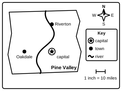
Get ready: use the map facts to answer.
- 1.
What does the star in a circle mean?
- 2.
What direction is Riverton from the capital?
- 3.
What direction is the capital from Oakdale?
- 4.
How many real miles is Riverton from the capital?
- 5.
What does the blue line show?
Challenge: Draw a tiny treasure map with a key and a compass rose.
Materials: ruler